
General development plans are the base of the spatial development of the municipalities and the settlements. The provisions of the general development plans with which is determined the general structure and the prevailing designation of the territories, the kind and the designation of the technical infrastructure and the protection of environment and the sites of cultural heritage shall be obligatory at preparing the detailed development plans. The rules and the normative for implementation of the general development plan are an inseparable part of the plan.
In accordance with the Spatial Development Act (Article 107) the general development plan of the municipality shall be worked out for the territories of all the settlements in it and shall determine:
- the general structure of the territory subject of the plan and the prevailing designation of its components and structural parts – the location and the boundaries of the territories of the settlements and settlement formations, the forest territories; the territories for protection of the environment, the territories for cultural and historic protection the damaged territories to be restored and the territories with special, other or mixed designation;
- the general development regime of each of the territories of item 1 with the corresponding rules and normatives;
- the location of the networks and the facilities of the technical infrastructure on the territory of the municipality and their connections with the territories of the neighbouring municipalities and with infrastructure networks, facilities and sites of national importance;
- the territories of public state and public municipal ownership and the regime of their development;
- the territories with probable occurrence of predictable natural calamities and the necessary preventing measures and spatial structure and protection;
- the territories for active application of landscape development measures and aesthetic arrangement.
Data from the topographic maps, the cadastre, the levelling plans, the specialised maps and registers etc. in digital and graphic form as well as other data from the specialised information systems of central and territorial administrations are used for working out the development plans.
The investigation and design works for compiling development plans implements in two phases: preliminary design and final design. The preliminary design of the plan should be subject to public discussion. The municipality publishes the graphic of the final design in digital form.
The investigation and the design of development plans, as well as the selection of development concept for them, shall be assigned by the order of the Public Procurement Act.
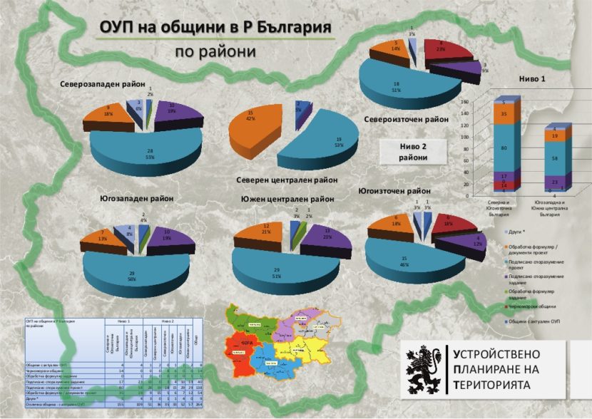
Financing of production of municipal general development plans is supported also with funds from the state budget. The Minister of Investment Planning (in 2013 and 2014) and the Minister of Regional Development and Public Works (after 2014) allocate the funds and provides methodological guidance, coordination and control for the assignment, production, agreeing upon and approval of the plans. As an expert in both ministries I was involved in the process and I had the honor to participate in financing over 90 and approval of 30 municipal general development plans.